Eastern Adrar
Eastern Adrar (combined 4x4 and camel trek, 11 days including 4 days of hiking; can be done in 8 days including 3 days of hiking)
The first part of this trip is a driving tour of one of the most beautiful regions of Adrar (Eastern Adrar).
The second part of this journey is a camel trek through the stunning Erg Ouarane area.
Highlights: Chinguetti – Ouadane – El Beyed – Guelb Richat – the pace of the camel caravan – overnight camps.
YOUR TRIP
J 1 Charter flight to Atar, “the gateway to the Mauritanian desert,” or a scheduled flight to Nouakchott.
Once the formalities are complete, we’ll meet you in the lobby of the Atar airport; after a short ride into town, we’ll arrive at our guesthouse (Auberge du Bonheur), where you’ll spend the night.
J 2 Atar - Aderg - El Beyed
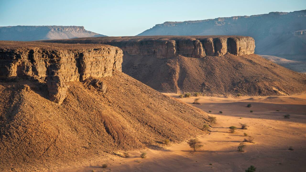
We leave Atar, heading east, into the foothills of the Adrar (the Baten).
We follow the Adrar cliff, passing through the palm grove and the village of Amder before arriving at “Dar Cheikh Mohamed Fadel” (the site consists of the tomb and house of a famous 17th-century religious leader). Next, we cross the dry bed of the Chemchame sebkha (the clay bottom of a Paleolithic lake), which stretches over 30 km.
Then we follow the impressive Makteir erg with its beautiful ochre dunes and its imposing inselberg called “Aderg,” before arriving at the Paleolithic site of El Beyed. Visit the rock art site and the Museum of Prehistory. Camp.
J 3 El Beyed - Guelb Er Richat - Ouadane
We set out in the morning for Guelb Errichat, a large buttress nicknamed “the Eye of the Earth” and a true geological enigma... truly exceptional!!
Visit to Guelb and the wooded camp nicknamed “Theodore Monod's Diocese.” Picnic.
"The most widely accepted explanation is that a magmatic dome formed at the intersection of fault lines about 100 million years ago and stopped growing before the dome could become a volcano. The ancient Cambrian sandstones, uplifted by the formation of the dome, were subsequently shaped by fractures and erosion to form this system of concentric cuestas that today gives Richat its somewhat mysterious character. After initially interpreting it as an astrobleme (a meteorite impact structure), geologists considered a symmetrical uplift (a circular anticline). But Th. Monod, who studied this phenomenon with a few colleagues, published, nearly half a century ago (Monod and Pomerol, 1973), hypotheses very close to the explanation commonly accepted today. Thus, since around 1980, it has been established that the Richat structure is that of an “alkaline complex” resulting from a particular form of volcanism dating back 100 million years (Cretaceous: end of the Mesozoic Era) that created a magmatic dome associated with hydrothermal activity (circulation of very hot water under very high pressure) This complex was formed during the opening of the Atlantic Ocean.”
We leave Guelb er Rîchat and head south toward Hassi Thibat. We catch sight of the remains of the old Portuguese fort of Agoueidir, built around 1446, before arriving in Ouadane. Overnight at the inn.
“Ouadane, formerly known as Iwaden (a Berber name), was corrupted to Ouadane in Arabic, meaning ‘the two wadis’: the wadi of knowledge, which is the city, and the wadi of dates, which is the valley. This fortified city remains a magnificent ancient city of Mauritania, founded in the 11th century and listed as a UNESCO World Heritage Site. It remains a city steeped in history and impresses all travelers who set foot in the Adrar region. The old part of the area overlooks a hill and catches the eye with its magnificent ruins.”
J 4 Ouadane - Tenochert - Mezrougatt
We leave Ouadane via the sand dunes, heading due west. We stop for a picnic in the beautiful little palm grove at Tenochert before passing through a narrow pass to exit Herour (an esker formed by a powerful glacial river). We arrive at the small semi-nomadic camp of Rghewiya. We set up camp amid the dunes at Mezrougatt.
J 5 Mezrougatt - Lemreyveg - Tweyiret
The camel trek begins in Mezrougatt. We start our camel trek through the beautiful interdune valleys, heading toward Lemreyveg in the Chinguetti Valley. We set up camp on a beautiful dune across from the small Tweyiret palm grove.
J 6 Tweyiret - Chinguetti
Continuing due west, we press on through the beautiful dunes of the Erg Ouarane toward the ancient caravan city of Chinguetti, where we arrive around midday. We visit one of the oldest libraries (containing ancient manuscripts) and the ruins of the ancient city of Chinguetti, considered the seventh holiest city in Islam. Overnight at the inn.
“Chinguetti has about ten libraries, four of which are open to the public. Some items in these collections date back to the 11th century, including some written on gazelle skins. Most of these works deal with religion and the Quran, but many cover science, geometry, or literature.
The city has been listed as a UNESCO World Heritage Site since 1996.”
J 7 Chinguetti - les M'Ghalig
We leave the old town of Chinguetti behind us and set off for Lagueyla. It is a pretty little palm grove nestled amid the semi-circular M'ghalig dunes (interdune valleys), which once served as trans-Saharan caravan trade routes. We stop for lunch under the palm trees of Lagueyla.
Then we continue our journey through the dunes, heading due west this time.
Camping in the middle of the M'ghalig.
J 8 M'Ghalig - Tinouagherit
Staying in the M'ghalig region, we continue walking through a landscape of rare and unimaginable beauty: vast dune fields stretch out one after another, all resembling one another, until the Ouarane erg comes to an end as it heads west toward Tinouagherit. We’ll take a lunch break under a beautiful acacia tree.
Our late-afternoon hike will take us across a stony reg dotted with barkhanes. We’ll set up camp facing Mount Zarga.
J 9 Tinouagherit - Guelb Er Raoui - Zarga
After a good half-hour’s walk, we reach the small sandstone massif of Zarga near the Guelb Eraoui. We visit the bat cave and its rock paintings. We have a picnic at Bir Aroueitine (well) before continuing our walk parallel to Mount Zarga. We camp in the Zarga massif.
The massive Zarga range (the variegated mountain) stretches 80 kilometers; it is what remains today of the bed of an ancient glacial river (440 million years old).
J 10 Zarga - Tichilit el Ateg
Traveling through the western foothills, we reach Tichilit el Âteg, a remarkable depression known for its beautiful dune. It is the highest point of the Zarga Massif and the third-highest peak in the Adrar. Lunch break.
In the afternoon, we return to Nouakchott.
J 11 Return flight to Paris.
